Detailed Town and Parish Maps go online for the first time
This exciting information has just been released by TheGenealogist:
TheGenealogist has added maps to its comprehensive National Tithe Records collection.
All aspects of society were captured by this survey
-
Identify the land your ancestors owned or occupied in the 19th century
-
Get an idea of their working lives by the usage made of the plots by your forebears.
-
Fully linked tithe maps for Middlesex, Surrey, Buckinghamshire and Leicestershire with other counties to follow shortly
-
Geographically placing where your ancestors worked and lived
-
In partnership with TNA, TheGenealogist is making it possible to search over 11,000,000 records from across England and Wales and to view theses valuable original apportionment documents with linked maps on one website.
It’s always been a challenge to find where our ancestors lived, but now these records can help you explore the fields and houses in their home villages and towns. Never before have family historians been able search nationwide for these ancestral maps. We plan to have complete coverage in the next few months.
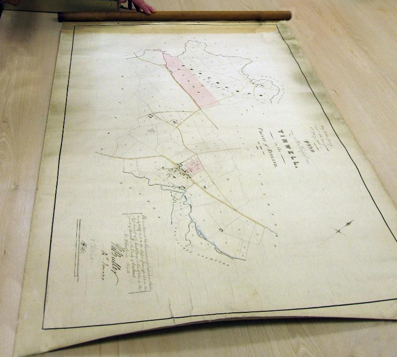
Tithe maps allow you to pinpoint your ancestors from our records. They show the boundaries of fields, woods, roads, rivers and the location and shape of buildings. The detail recorded within the maps and apportionment records will show you how much land they owned or occupied, where exactly in the parish it was, what the land was used for and how much tithe rent there was to pay.

The Tithe Commissioners maps are now housed in The National Archives (TNA). Due to their age and the materials used the original maps are often too fragile to handle. These were microfilmed in 1982 and some of the maps have deteriorated over the last 30 years. The first stage of the project is the release of these as online images.
There are over 12,000 main maps plus thousands of update maps as the boundaries of fields changed over time.
The second stage will be the delicate conservation and digitisation of the original colour maps.
“Tithe records are a rich resource for family historians as they cover owners and occupiers of land from all strata of early Victorian society.
These maps can be three to four meters in length by several meters in width and have gone through a multiple levels of digitisation and processing so that the huge maps can load instantly, even on a mobile phone. This fantastic resource was created in the period from 1837 to the early 1850s as a result of one of the largest surveys into the usage, ownership and occupation of land in England and Wales since the Domesday book.”
Mark Bayley - Head of Online Content at TheGenealogist
Diamond subscribers to TheGenealogist are able to view apportionment records for all of England & Wales, with the accompanying maps now being live for Middlesex, Surrey, Buckinghamshire and Leicestershire. The maps for the rest of England and Wales will follow over the coming months.
See their page TheGenealogist.co.uk/Tithe to freely search the records and learn more about them.
Here is an example provided by TheGenalogist:
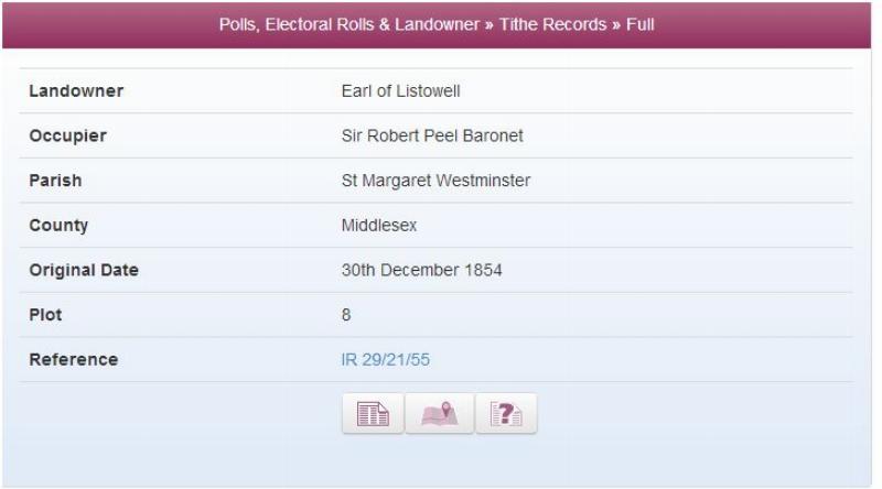
Sir Robert Peel in the Tithe records.
We can look for Sir Robert Peel in Middlesex, a county that covered some of the area we would now think of as London. By selecting Landowner Records and then from the drop down menu Tithe Records we then enter Robert Peel into the name fields.
In 1854 Sir Robert, twice Prime Minister of the country and creator of the modern police force, was the occupier of land that was owned by the Earl of Listowell in St Margaret’s, Westminster.
By clicking on the Transcription icon we can then see the names of both the owner and occupier, the date it was entered into the records and the plot number on the plan.
The image of the apportionment reveals that it is a house: No. 22 Princess Gate.
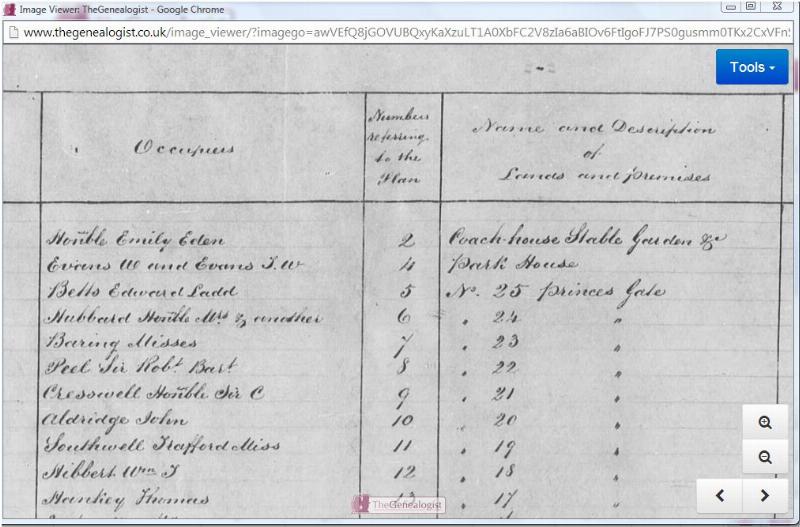
By clicking on the map icon will quickly zoom the researcher in to see the plot on the plan. You can then use the magnify buttons to move in and out to see the plots in relation to the full plan of the parish.
Tithes are a rich resource for family historians to find their ancestors within. The records and maps cover owners and occupiers of land from all strata of society in early Victorian times.
For a special offer of £20 off TheGenealogist Diamond Subscription go to:
www.thegenealogist.co.uk/tithe20