Welcome to the Family History Social

The very latest news from the world of genealogy

Categories

More...

See where your ancestors lived in 1861


Family history website TheGenealogist has announced today an exciting new feature as part of their powerful Map Explorer™ tool. For the first time, you can explore 1861 census records for England, Scotland and Wales seamlessly connected to contemporary maps with pins revealing the parish, thoroughfare, or even the very building where your ancestor lived. This enhancement adds a fascinating layer to your research and exploration.


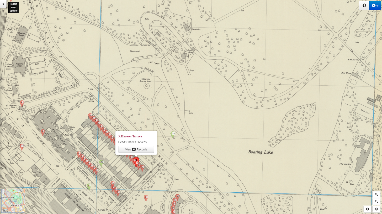
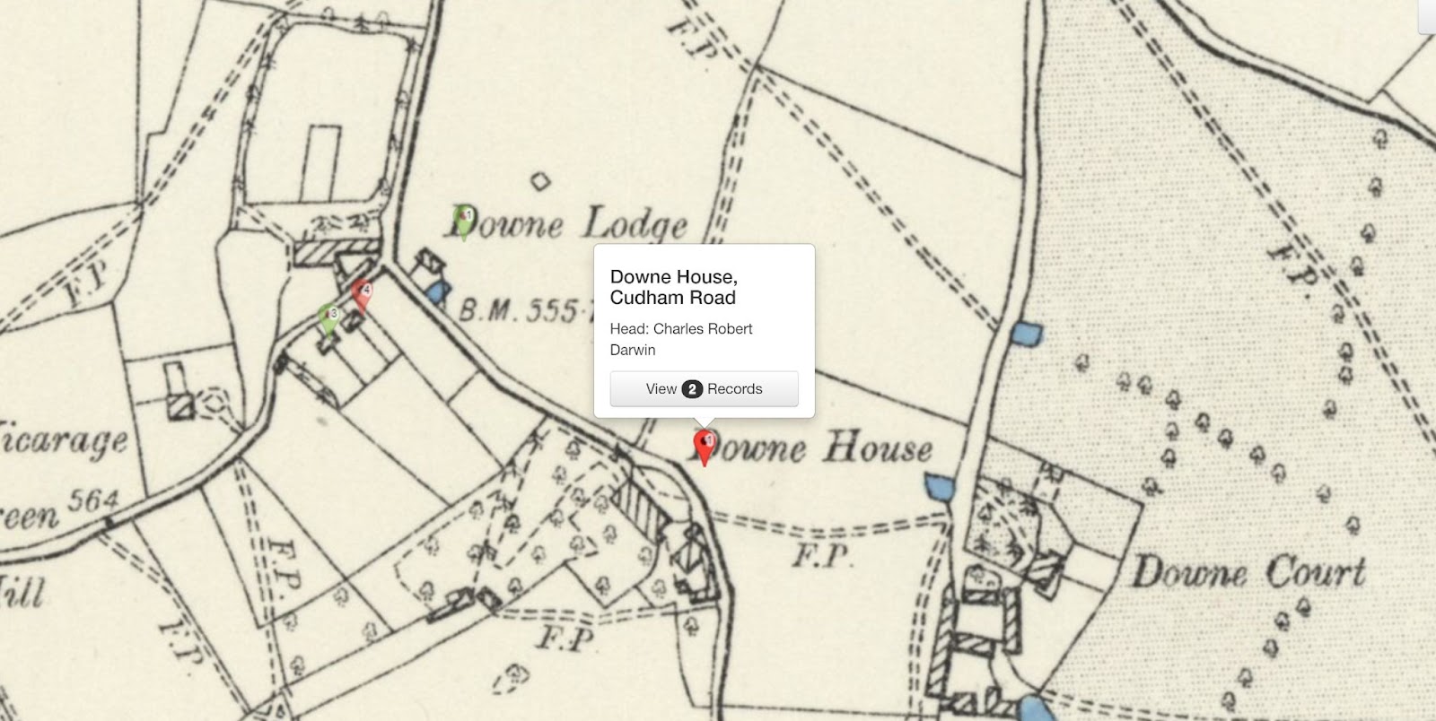
Charles Dickens location in the 1861 census displayed on Map Explorer™

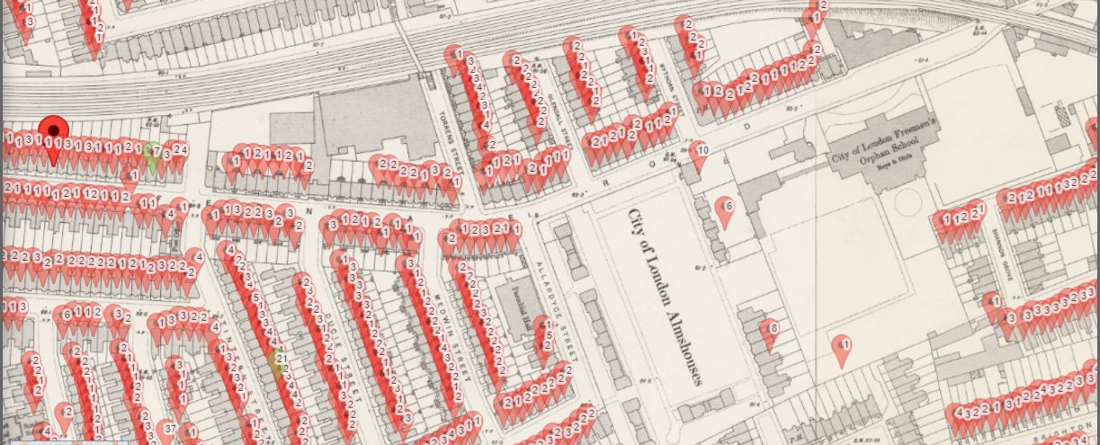
Family historians and house historians will now find it easier than ever to locate a person in the official population count from 1861. With one click, you can view a historic map with a pin indicating where a person was living in that year. 


You can then go on to see the routes your ancestors would have used to visit shops, local pubs, churches, places of work, schools and parks. You can also find where the nearest railway station was, important for understanding how our ancestors could travel to other parts of the country to see relatives or visit their hometown.


The 1861 Census joins previously released 1871 to 1911 censuses and the 1939 Register, which are all linked to TheGenealogist’s innovative Map Explorer™. This means that with just the click of a button, you can travel in time through 7 decades of records to discover future occupants and see how an area changed.


Most of the Greater London area and other towns and cities can be viewed down to the property level, while other more rural parts of the country can be identified down to the parish, road or street.


Read TheGenealogist’s article: Where the Dickens Are They? to discover more and see an interesting case study: 

https://www.thegenealogist.co.uk/featuredarticles/2024/where-the-dickens-are-they-7061/ 


Save Over 50% on our Diamond Personal Premium Package

To celebrate this latest release, TheGenealogist is offering its Diamond Personal Premium Package for only £98.95 a saving over 50%.

This offer includes a lifetime discount! Your subscription will renew at the same discounted price every year you stay with us.

To find out more and claim the offer, visit: https://www.thegenealogist.co.uk/MGBCEN224

This offer expires at the end of 23rd May 2024


About TheGenealogist


TheGenealogist is an award-winning online family history website, who put a wealth of information at the fingertips of family historians. Their approach is to bring hard to use physical records to life online with easy to use interfaces such as their Tithe and newly released Lloyd George Domesday collections. 


TheGenealogist’s innovative SmartSearch technology links records together to help you find your ancestors more easily. TheGenealogist is one of the leading providers of online family history records. Along with the standard Birth, Marriage, Death and Census records, they also have significant collections of Parish and Nonconformist records, PCC Will Records, Irish Records, Military records, Occupations, Newspaper record collections amongst many others.


TheGenealogist uses the latest technology to help you bring your family history to life. Use TheGenealogist to find your ancestors today!

Leave a comment

New Release: 1871 UK Census households now plotted on Map Explorer™

The 1871 Census for England, Scotland and Wales has, for the first time, been georeferenced on TheGenealogist. This is the process of linking a record to a geographical spot and means you can now see where a household stood with links to detailed maps on the powerful Map Explorer™. This is set to make investigating the places where ancestors lived in this year even more interesting for family and house historians. 


Viewing a household record from the 1871 census on TheGenealogist will now show a map pinpointing its location. Clicking through from this preview map opens the powerful Map Explorer™ with its georeferenced modern and historical maps. This then enables subscribers to explore their ancestors’ area in much greater detail than on other census sites.


1871 census household pinpointed on Map Explorer™ 


Joining the earlier census releases, which saw the 1911, 1901, 1891 and 1881 census linked up to the powerful mapping tool, researchers can now easily identify with just the click of a button where their forebears had once lived and get a sense of the routes their ancestors used. 


Using these linked maps allows researchers to trace the thoroughfares that ancestors may have walked down as they went shopping, or popped into their local pubs for a drink. Researchers can likewise, work out the routes that their forebears may have taken to get to their nearby churches, or find the shortest way to their places of work and the direction they needed to go in order to reach their nearby park for relaxation. Historical maps can also reveal where the nearest railway station was to their home, important for understanding how our ancestors could have travelled to other parts of the country to see relatives or to visit their hometown.


With this powerful resource, Starter, Gold and Diamond subscribers of TheGenealogist can look into their ancestors’ neighbourhood from home on their computer screens, or even access the census and the relevant maps on their mobile phone as they walk down the modern streets.


The Greater London Area, Buckinghamshire and Berkshire along with most towns and cities can be viewed down to the property level, while other parts of the country will identify down to the parish, road or street.


Albert Mansions and Albert Hall


In this particular census year, Queen Victoria opened the Royal Albert Hall, Gilbert and Sullivan premiered the first of their light opera collaborations at the Gaiety Theatre in London and a technologically advanced lighthouse was switched on near Tyne and Wear. 


Read TheGenealogist's article “Putting 1871 on the map” to discover more as Nick Thorne takes a look at events in 1871 and brings context to the census records. https://www.thegenealogist.co.uk/featuredarticles/2023/putting-1871-on-the-map-1673/ 


About TheGenealogist

TheGenealogist is an award-winning online family history website, who put a wealth of information at the fingertips of family historians. Their approach is to bring hard to use physical records to life online with easy to use interfaces such as their Tithe and newly released Lloyd George Domesday collections. 

TheGenealogist’s innovative SmartSearch technology links records together to help you find your ancestors more easily. TheGenealogist is one of the leading providers of online family history records. Along with the standard Birth, Marriage, Death and Census records, they also have significant collections of Parish and Nonconformist records, PCC Will Records, Irish Records, Military records, Occupations, Newspaper record collections amongst many others.

TheGenealogist uses the latest technology to help you bring your family history to life. Use TheGenealogist to find your ancestors today!


Leave a comment

New Release: 1881 Census on Map Explorer™

Where did my ancestors live? Were the shops, churches and pubs nearby? 


These questions and more are now easier than ever to answer using TheGenealogist. This online family history website has just linked all of its 1881 census records of England, Scotland and Wales to its powerful Map Explorer™ so that users can see the locations of houses plotted on georeferenced historic and modern map layers.


Uniquely on TheGenealogist viewing a household record from the 1881 census will now show a map pinpointing its location. Clicking on this pin opens Map Explorer™, enabling subscribers to explore the area and see the records of neighbouring properties.


With this new release family and house historians are able to research the streets, lanes and neighbourhoods in which their ancestors had lived at the time of the 1881 census. Joining earlier releases that saw the 1911, 1901 and 1891 census linked to the powerful mapping tool, researchers can easily identify with just the click of a button, where their forebears had once lived. 


With properties plotted on a map researchers can see the routes their ancestors could have used to get to the shops, drop into their local pubs, worship at their nearby churches, travel to their places of work and relax with a walk in the nearby park. Historical maps make it possible to find where the nearest railway station was to their home, important for understanding how our ancestors could have travelled to other parts of the country to see relatives or visit their hometown.


Using this powerful resource, Starter, Gold and Diamond subscribers of TheGenealogist can investigate their ancestors’ neighbourhood from home on their computer screens, or even access the census and the relevant maps on their mobile phone while walking down the modern streets.


The majority of the London area and other towns and cities can be viewed down to the property level, while other parts of the country will identify down to the parish, road or street.


Charles Darwin’s home, Downe House


See TheGenealogist’s article: Darwin at Downe

https://www.thegenealogist.co.uk/featuredarticles/2022/darwin-at-downe-1637/ 


About TheGenealogist

TheGenealogist is an award-winning online family history website, who put a wealth of information at the fingertips of family historians. Their approach is to bring hard to use physical records to life online with easy to use interfaces such as their Tithe and newly released Lloyd George Domesday collections. 

TheGenealogist’s innovative SmartSearch technology links records together to help you find your ancestors more easily. TheGenealogist is one of the leading providers of online family history records. Along with the standard Birth, Marriage, Death and Census records, they also have significant collections of Parish and Nonconformist records, PCC Will Records, Irish Records, Military records, Occupations, Newspaper record collections amongst many others.

TheGenealogist uses the latest technology to help you bring your family history to life. Use TheGenealogist to find your ancestors today!

Leave a comment

Maps for family historians and using them to explore the past

Maps are one of the most important visual aids that a family, social or house historian can turn to when exploring the homes of our ancestors. We may have already come across a record that has provided us with an address, or maybe all we have is just a place name, and we want to explore the surrounding streets or the area.


Tithe map of Sedbergh, Yorkshire courtesy of The National Archives

There are various types of map resources that we can use to step back in time, get a better understanding of the landscape that our ancestors would have been living in. By seeing the environment in which they had once lived enables us to see roads, rivers and railways that can explain where they moved on to, or where they had come from in the first place. 


Another line that we may research with the use of a map is for determining employment opportunities for people who had lived in a particular place in a particular time. The map could show us employment opportunities whether they were farms, mills, mines or some type of industrial building such as factories, distilleries, breweries and so on that had attracted our ancestors to live in that place.


Colour Tithe map of the Parish of St Cuthbert in York


Maps can reveal other fascinating information that can be useful in our research, for example we can often see who the landowners were and a historical map allows us to work out the nearest church or nonconformist chapel to where our ancestors lived. With this knowledge the researcher can then look for their forebears' baptisms, marriages and burials in the relevant records connected to that church/chapel.


We can use a range of maps from modern street maps of City & Town maps to historical maps drawn up in the past. Often the problem with a modern map is that they only show us the lay of the land as it is today and not as it may have been when our forebears walked the highways and byways of the area that we are investigating. Many places have seen significant changes over the years with modern redevelopments replacing previous settlements or roads that had first been laid out in medieval times.


A useful set of maps for investigation where an early Victorian era English or Welsh ancestor may have lived are the Tithe Maps. The Tithe Survey which was responsible for the creation of the Tithe Maps was as a result of  the Tithe Commutation Act 1836 and covered a large part of the country that was still subject to tithes and had not been enclosed. These maps and their accompanying apportionment books can be used to discover where people were living and who their neighbours were in the period of the survey from 1836 to the 1850s. Three sets were made of each area, one for the parish, one for the diocese and one for the Tithe Commissioners in London. This last set is in the safekeeping of The National Archives at Kew and have been digitised and put online by commercial family history website TheGenealogist. The parish and diocese maps are likely to be at the diocesan archive which may not necessarily be the county record office for the town/area that you are researching as some ecclesiastical dioceses' boundaries included parts of neighbouring counties. Tithe maps include both owners and occupier’s names and so are useful for family historians  delving into their family history. The maps can often show details such as boundaries, roads, waterways, buildings and woodlands. Sometimes these Victorian era maps show other details such as hedges, field names, mines and factories.


What maps can I use to research my ancestors’ stories?


There have been many maps drawn up over time. Some of these maps are more useful to us than others for researching our family history, although there can be occasions we need to consult a more specialist map such as when doing a house history. A list of maps that a family, social or house historian could use can be seen at https://www.map-explorer.co.uk/

Many of these maps can be found in the local County Record Office though quite a few, but not all, are becoming available on the internet. 


One of the most useful tools for family, social and house historians is the powerful online Map Explorer™ that is accessed on the subscription website TheGenealogist. Boasting a number of georeferenced historic as well as modern maps this resource allows its users to see the plots relating to historical records, such as the Tithe Survey and then fade between the different map layers. Because the historic and modern maps are matched to the same coordinates the researcher can view where an ancestor may have once occupied a small cottage and garden, or even a large estate with many fields, woods and so on. Once found it is then easy to use this tool to see what is there today. As urban boundaries have encroached the countryside it is sometimes fascinating to see how rural what we now see as city suburbs was in our ancestors’ time. 


Map Explorer™ with its georeferenced historical and modern maps includes not only Tithe Records and Maps to look for your Victorian ancestors’ homes, but also Inland Revenue Valuation Office (Lloyd George Domesday Survey) Records and Maps for nearly one million individuals. Other useful record set layers include Census records, Headstones and War memorials and the mapping interface now also allows users the ability to also see what their ancestors’ towns and areas in the U.K. had once looked like as it now includes historical pictures. This sees the addition of period photographs of street scenes and parish churches where researchers' ancestors may have been baptised, married and buried, added to the maps as a recordset layer. The various images for an area have their locations pinpointed on the maps, allowing family historians to explore their ancestors’ hometowns and other landmarks from around their area.


Important repositories of maps include:

The National Archives

Ruskin Avenue,

Kew,

Richmond,

Surrey TW9 4DU https://www.nationalarchives.gov.uk


British Library at St. Pancras

96 Euston Road,

London NW1 2DB https://www.bl.uk/


Bodleian Library

Broad Street,

Oxford OX1 3BG https://www.bodleian.ox.ac.uk/


Leave a comment

Now view your ancestors’ homes from the 1901 census on georeferenced maps

Millions of homes recorded in the 1901 census have now been plotted on historical georeferenced maps by TheGenealogist. Family history or house historians can now explore the areas where their ancestors lived and see how far it was for them to walk to the shops, visit their local pub, travel to work or take a train to another city or town.


Following on from their recent releases of the 1939 Register and the 1911 Census records linked to contemporary and modern map layers on TheGenealogist’s Map Explorer™, now the same innovative features have been applied to the 1901 Census of England and Wales. 


With this release Diamond subscribers are able to pinpoint where their ancestors’ properties were at the time of the census count and so metaphorically walk the streets from the comfort of their home. Alternatively, users may access TheGenealogist on their mobile phone to physically discover the neighbourhood while on the move.


This key tool can make the lives of the family or house historian easier than ever to research census records for buildings and the newly linked 1901 census complements the rich georeferenced Lloyd George Domesday Survey and Tithe records that are already available on TheGenealogist’s Map Explorer™ as well as the 1939 Register and the 1911 Census records recently added to this website.


The majority of the London area and other towns and cities are viewable down to the property level, while other parts of the country will identify down to the parish, road or street.


With this new release, viewing a household record from the 1901 census will now show a map, locating your ancestors' house. Clicking on this map loads the location in Map Explorer™, enabling you to explore the area and see the records of neighbouring properties.


See TheGenealogist’s article about the 1901 Census on MapExplorer™: The Clog Dancers house and the paths they would have trodden. https://www.thegenealogist.co.uk/featuredarticles/2022/the-clog-dancers-house-and-the-paths-they-would-have-trodden-1560/ 


Find out more at TheGenealogist.co.uk/map

Leave a comment
Found 5 Results.
Back to top