Welcome to the Family History Social

The very latest news from the world of genealogy

Categories

More...

TheGenealogist adds 2,738 more parishes of Tithe Maps to Map Explorer™


TheGenealogist’s Map Explorer on a mobile phone, using the “Locate Me” feature whilst visiting Lacock Abbey, Wiltshire. Cycling through a Modern Satellite Image, Modern Map, 1890’s OS Map and 1838 Tithe Map


Over 30 counties of georeferenced Tithe Maps have been added to date!

TheGenealogist’s Map Explorer™, the resource for researchers to turn to when searching for an ancestor’s landholding whether owned or simply occupied, has been boosted with the significant addition of georeferenced Tithe Maps for Anglesey, Durham, Devon, Shropshire, Somerset, Suffolk and Wiltshire. 


From cottages with gardens to acres of farmed land and country estates, the addition of georeferenced Tithe maps as a layer over modern and other historical maps will allow researchers to see how the landscape changed over time. Map Explorer™ gives the researcher the ability to switch between layers of tithe, historical and modern maps which are all tied to coordinates and so allow the user the ability to see how places change over the years. 


From a plot identified on the tithe map it is possible to click through to then see the description as it was recorded in the apportionment record at the time, thus revealing more about what an ancestor’s holding had been. Using Map Explorer™ the family historian can browse an ancestor’s area to find other plots that they owned or occupied. Alternatively, TheGenealogist’s Master Search can be used to look for ancestors’ plots across the tithe records and then view them on Map Explorer™.


Lacock Abbey on a tithe map


Subscribers accessing TheGenealogist on their mobile devices, while out walking, can use the “locate me” function when using the tool on the move and so open up the history of what is around them. This is explored further in their featured article (see the link below).

  • Total number of maps in this release is 2,738
  • Total number of Tithe maps in Map Explorer™ is now 9,710
  • Map Explorer™ has over four million viewable records indicated by Map Pins
  • TheGenealogist’s Map Explorer™ displays maps for historical periods up to the modern day.

The addition to Map Explorer™ this week of the black and white tithe maps for Anglesey, Durham, Devon, Shropshire, Somerset, Suffolk and Wiltshire, linked to the apportionment books, will enable researchers to discover ancestors who both owned or occupied property between 1837 and the 1850s, with some additional altered apportionments in later years when property was sold or divided. The records allow TheGenealogist’s Diamond subscribers to find details of the plots, the owners of the land, as well as the occupiers at the time of the survey while also identifying the actual plots on the maps. Tithes usefully record all levels of society from large estate owners to occupiers of small plots such as a homestead or a cottage. 


With this addition, Map Explorer™ now features colour tithe maps for the counties of Buckinghamshire, Cumberland, Essex, Huntingdonshire, Middlesex, Northumberland, Rutland, Surrey, Westmorland, the City of York as well as North and East Ridings of Yorkshire plus black and white maps for Anglesey, Berkshire, Cambridge, Cheshire, Durham, Devon, Dorset, Hertfordshire, Kent, Lancashire, Leicestershire, Lincolnshire, Norfolk, Oxfordshire, Shropshire, Somerset, Staffordshire Suffolk, Yorkshire West Riding and Wiltshire. 


See TheGenealogist’s article: Traveling back in time with MapExplorer™ in your hand: https://www.thegenealogist.co.uk/featuredarticles/2021/traveling-back-in-time-with-mapexplorer-in-your-hand-1386/


Find out more at TheGenealogist.co.uk/maps/


About TheGenealogist


TheGenealogist is an award-winning online family history website, who put a wealth of information at the fingertips of family historians. Their approach is to bring hard to use physical records to life online with easy to use interfaces such as their Tithe and newly released Lloyd George Domesday collections. 


TheGenealogist’s innovative SmartSearch technology links records together to help you find your ancestors more easily. TheGenealogist is one of the leading providers of online family history records. Along with the standard Birth, Marriage, Death and Census records, they also have significant collections of Parish and Nonconformist records, PCC Will Records, Irish Records, Military records, Occupations, Newspaper record collections amongst many others.


TheGenealogist uses the latest technology to help you bring your family history to life. Use TheGenealogist to find your ancestors today!

Leave a comment

TheGenealogist adds extra tithe maps to Map Explorer™

Powerful new map tool now helps trace ancestors land or property with further additions of Tithe Maps

TheGenealogist’s Map Explorer™ which can help researchers find an ancestor’s property and watch the landscape change over time has now been enhanced by the addition of georeferenced black and white Tithe Maps for Berkshire, Cambridgeshire, Leicestershire and Oxfordshire.


  • Total number of maps in this release is 927
  • Total number of Tithe maps in Map Explorer™ is 3,317
  • Map Explorer™ has over two million selectable records shown using Map Pins

Joining the georeferenced Lloyd George Data Layer, Headstones, War Memorials, and colour Tithe Maps for a number of counties, the new additions to the ever-expanding Map Explorer™ allow researchers to trace property from Victorian times to the modern era.


Great Coxwell Tithe Barn Oxfordshire (was Berkshire) used to store original tithe contributions of crops. 

Photo by Motacilla / CC BY-SA (https://creativecommons.org/licenses/by-sa/4.0)


  • TheGenealogist’s Map Explorer™ displays maps for historical periods up to the modern day.
  • Various colour and black and white Tithe maps have now been added to this innovative tool and linked to the apportionment books, enabling researchers to locate where their ancestors lived or worked.

The addition to the Map Explorer™ of the black and white tithe maps for Berkshire, Cambridgeshire, Leicestershire and Oxfordshire linked to the apportionment books will enable researchers to find the details of the plots, their owners and their occupiers at the time that the survey was taken in Victorian times while also identifying the plots on the maps. By using the Map Explorer™ controls the researcher can then see how the landscape changes over time with the aid of the georeferenced historical and modern map layers. Tithe maps and records were drawn up from 1836 to the 1850s, with additional altered apportionments in later years when property was sold or divided. Tithes usefully record all levels of society from large estate owners to occupiers of small plots such as a homestead or a cottage. 


The Map Explorer™ now features colour tithe maps for the counties of Buckinghamshire, Cumberland, Essex, Huntingdonshire, Middlesex, Northumberland, Rutland, Surrey, Westmorland, the City of York as well as North and East Ridings of Yorkshire plus black and white maps for Berkshire, Cambridge, Leicestershire and Oxfordshire.


See our article: Tithe Maps on Map Explorer

https://www.thegenealogist.co.uk/featuredarticles/2020/tithe-records-on-map-explorer-1255/


Find out more at TheGenealogist.co.uk/maps/


About TheGenealogist

TheGenealogist is an award-winning online family history website, who put a wealth of information at the fingertips of family historians. Their approach is to bring hard to use physical records to life online with easy to use interfaces such as their Tithe and newly released Lloyd George Domesday collections. 


TheGenealogist’s innovative SmartSearch technology links records together to help you find your ancestors more easily. TheGenealogist is one of the leading providers of online family history records. Along with the standard Birth, Marriage, Death and Census records, they also have significant collections of Parish and Nonconformist records, PCC Will Records, Irish Records, Military records, Occupations, Newspaper record collections amongst many others.


TheGenealogist uses the latest technology to help you bring your family history to life. Use TheGenealogist to find your ancestors today!

Leave a comment

Changing times in the latest map release from TheGenealogist


TheGenealogist has released the Colour Tithe Maps for Essex with full integration with its MapExplorer™. This release allows us to see the area in West Ham, Essex on which the ExCel centre now stands and to discover the changes from Victorian pasture land, to dock complex then Exhibition venue and now to the Nightingale Hospital as the Covid-19 emergency builds.


This versatile tool can give the family history researcher a fantastic insight into what our ancestors’ city, town or village looked like over a number of periods and can also help them to find an ancestor’s property. With the addition of georeferenced Colour Tithe Maps. TheGenealogist has also today released colour tithe maps for Essex – you can search these as normal or browse them on Map Explorer™. 


Joining the georeferenced Lloyd George Data Layer, Headstones and War Memorials, the Colour Tithe Maps are an important enhancement of the ever-expanding Map Explorer™.


  • The Map Explorer™ displays maps for historical periods up to the modern day.
  • Colour Tithe maps bring the early Victorian era to this innovative tool
  • Plots on the maps are linked to the apportionment books, enabling researchers to locate where their ancestors lived or worked

TheGenealogist has linked these highly detailed Tithe maps to the apportionment book records so providing researchers with the details of the plots, their owners and their occupiers at the time of the early Victorian survey. The coverage ranges from large estate owners to ordinary people occupying small plots such as a homestead or a cottage. Colour Tithe Maps make it easier for the researcher to understand the terrain as the streams, rivers, lakes, ponds, houses and trees are often highlighted in different colours. 


TheGenealogist’s Colour Tithe Maps now cover the counties of Buckinghamshire, Cumberland, Huntingdonshire, Middlesex, Northumberland, Rutland, Surrey, Westmorland, the City, North and East Ridings of Yorkshire along with the new addition this week of Essex. 


Subscribers to TheGenealogist’s Diamond membership can now view the latest colour or grayscale maps when using the Tithe & Landowner records.


TheGenealogist’s powerful Map Explorer™ has been developed to view these georeferenced historic maps overlaid on top of modern background maps including those from Ordnance Survey and Bing Street maps, as well as a satellite view. With the Map Explorer™, you can search for an ancestor's property, discovering its site, even if the road has changed or is no longer there. 


Alternatively, using the Master Search on TheGenealogist, having found your forebear listed in the Tithe Records you can click through to the Map Explorer™ which will also show War Memorials or cemeteries on the various maps.


Read TheGenealogist’s article here: 

https://www.thegenealogist.co.uk/featuredarticles/2020/essex-tithe-maps-reveal-ever-changing-landscape-1239/


About TheGenealogist


TheGenealogist is an award-winning online family history website, who put a wealth of information at the fingertips of family historians. Their approach is to bring hard to use physical records to life online with easy to use interfaces such as their Tithe and newly released Lloyd George Domesday collections. 


TheGenealogist’s innovative SmartSearch technology links records together to help you find your ancestors more easily. TheGenealogist is one of the leading providers of online family history records. Along with the standard Birth, Marriage, Death and Census records, they also have significant collections of Parish and Nonconformist records, PCC Will Records, Irish Records, Military records, Occupations, Newspaper record collections amongst many others.


TheGenealogist uses the latest technology to help you bring your family history to life. Use TheGenealogist to find your ancestors today!


Leave a comment

North Buckinghamshire

TheGenealogist has just released the North Buckinghamshire maps and field books into its property ownership and occupancy record set, The Lloyd George Domesday Survey. This unique online resource allows researchers to discover where an ancestor lived in the 1910-1915 period from various London districts and now, for the first time, North Buckinghamshire.


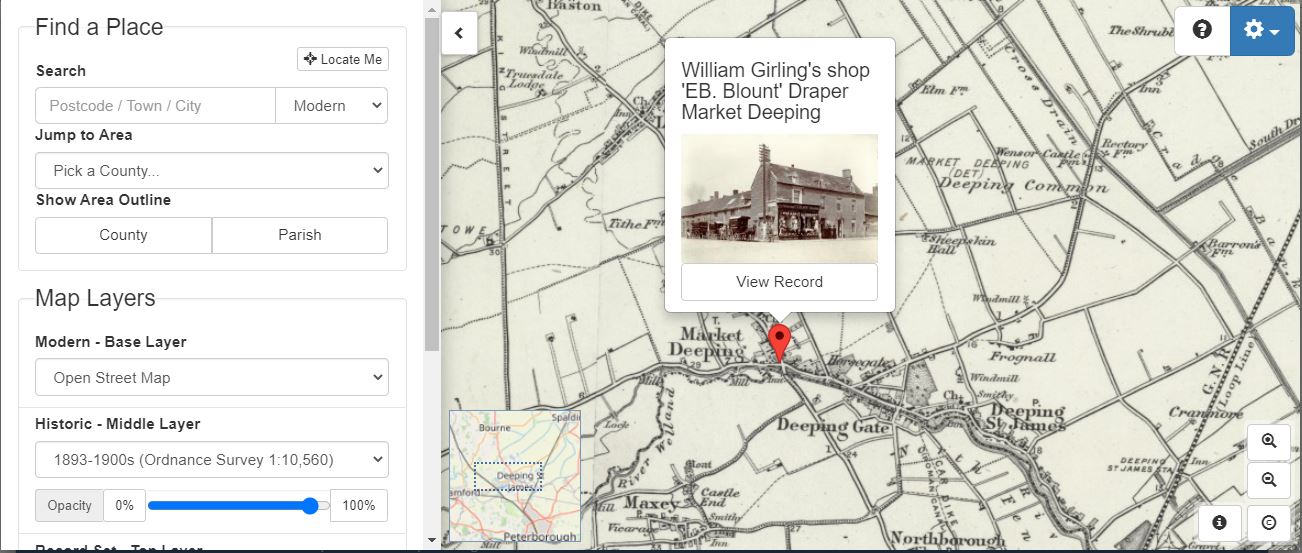
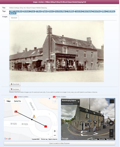
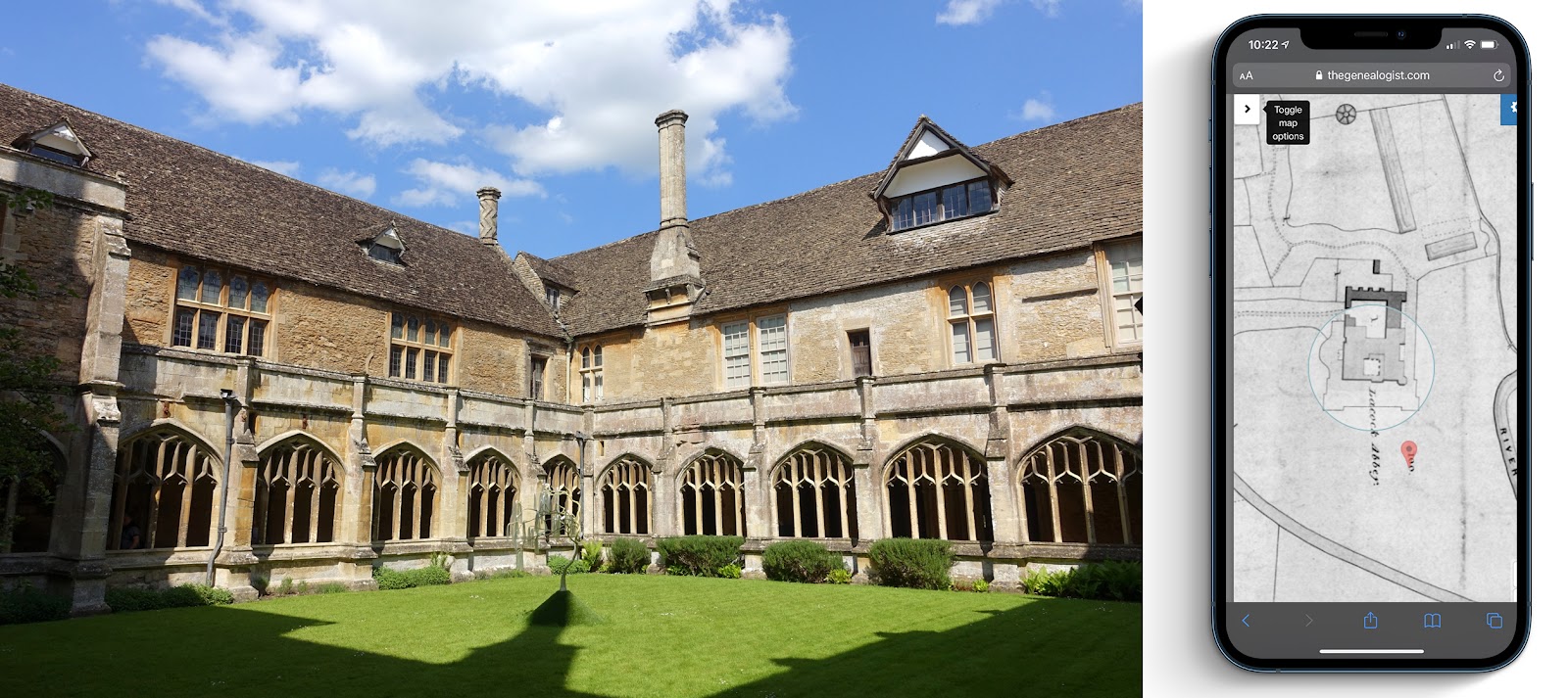
These records make use of TheGenealogist’s powerful new Map Explorer to access the maps and residential data, giving those who want to discover where their ancestors lived in the period before the First World War some powerful new features to use. The Lloyd George Domesday Survey records are sourced from The National Archives and are being digitised by TheGenealogist so that it is possible to precisely locate where an ancestor lived on large scale, hand annotated maps. These plans include plots for the exact properties and are married to various georeferenced historic map overlays and modern base maps on the Map Explorer™ which allows the researcher to thoroughly investigate the area in which an ancestor lived. 


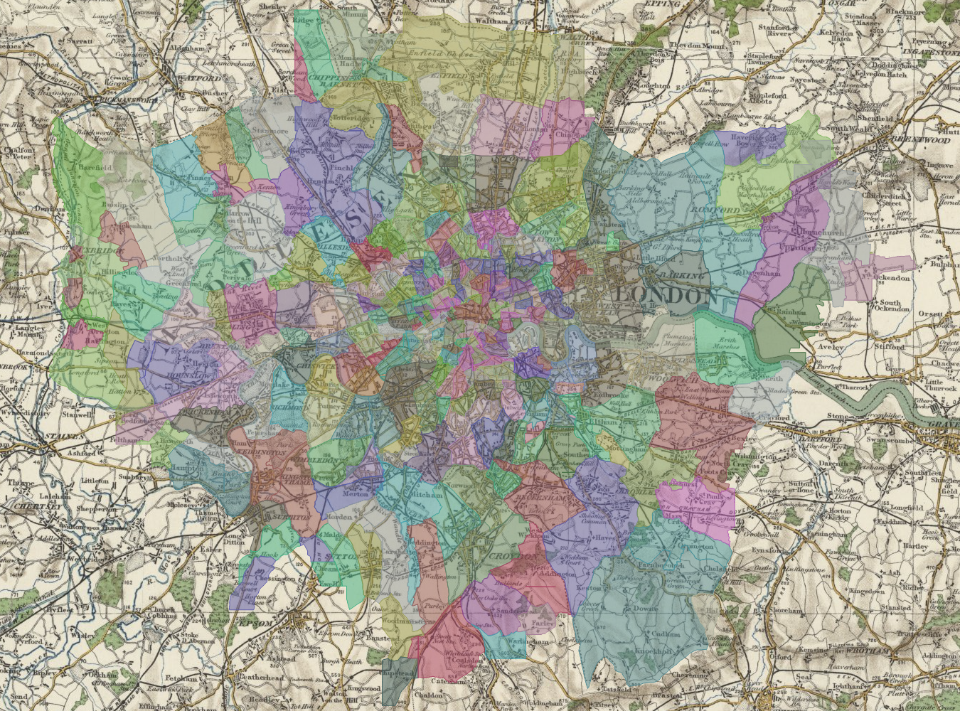
Buckingham, North Buckinghamshire Valuation Office Maps


This release includes the following places: Addington, Akeley, Ashendon and Dorton, Aston Abbotts and Wingrave, Aston Clinton, Aston Sandford, Astwoo, Aylesbury, Barton Hartshorn, Beachampton, Biddlesden, Bierton, Bletchley, Boarstall, Bow Brickhill, Bradwell, Broughton, Buckingham, Calverton, Castlethorpe, Charndon, Chearsley and Long Crendon, Cheddington, Chicheley, Clifton Reynes, Cold Brayfield, Creslow and Whitchurch, Cublington, Cuddington, Dinton, Stone and Hartwell, Drayton Beauchamp, Drayton Parslow and Mursley, Dunton and Hoggeston, East Claydon, Edgcott and Marsh Gibbon, Edlesborough, Emberton, Fenny Stratford, Fleet Marston and Quarrendon, Foscott, Gayhurst, Grandborough, Hogshaw and North Marston, Great and Little Brickhill, Great Horwood, Great Linford, Grendon Underwood, Haddenham, Halton and Wendover, Hanslope, Hardwick and Weedon, Haversham, Hillesden, Ickford, Ivinghoe, Kingsey, Kingswood and Ludgershall, Lillingstone, Linslade and Soulbury, Loughton, Luffield Abbey and Stowe, Marsworth and Pitstone, Mentmore, Milton Keynes, Nash, Newport Pagnell, Newton Longville, Olney, Oving and Pitchcott, Padbury, Quainton, Radclive, Ravenstone, Shalstone, Shenley Brook End, Simpson, Steeple Claydon, Stewkley, Stoke Hammond, Stoke Mandeville, Studley, Swanbourne and Winslow, Thornborough, Tingewick, Turweston, Upper and Lower Winchendon, Waddesdon, Walton, Water Eaton, Wavendon, Weston Turville, Wing, Wolverton, Woolstone and Woughton, Wotton Underwood.


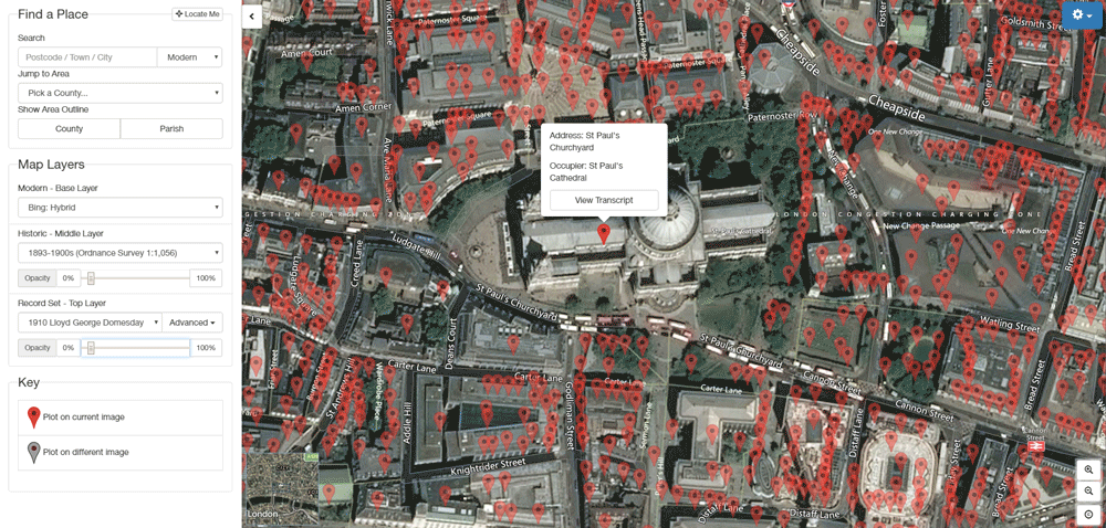
Bletchley Park shown in the Map Explorer from TheGenealogist


  • TheGenealogist’s Lloyd George Domesday records link individual properties to extremely detailed maps used in 1910-1915
  • Fully searchable by name, county, parish and street
  • The maps will zoom down to show the individual properties as they were in the 1910s
  • The transparency slider reveals a modern street map underlay
  • Change the base map displayed to more clearly understand what the area looks like today


Read our article on finding Bletchley Park in these records:

https://www.thegenealogist.co.uk/featuredarticles/2019/north-buckinghamshire-maps-reveal-bletchley-park-1194/


About TheGenealogist


TheGenealogist is an award-winning online family history website, who put a wealth of information at the fingertips of family historians. Their approach is to bring hard to use physical records to life online with easy to use interfaces such as their Tithe and newly released Lloyd George Domesday collections. 


TheGenealogist’s innovative SmartSearch technology links records together to help you find your ancestors more easily. TheGenealogist is one of the leading providers of online family history records. Along with the standard Birth, Marriage, Death and Census records, they also have significant collections of Parish and Nonconformist records, PCC Will Records, Irish Records, Military records, Occupations, Newspaper record collections amongst many others.


TheGenealogist uses the latest technology to help you bring your family history to life. Use TheGenealogist to find your ancestors today!


 About The National Archives

The National Archives is one of the world’s most valuable resources for research and an independent research organisation in its own right. As the official archive and publisher for the UK government, and England and Wales they are the guardians of some of the UK's most iconic national documents, dating back over 1,000 years. Their role is to collect and secure the future of the government record, both digital and physical, to preserve it for generations to come, and to make it as accessible and available as possible. The National Archives brings together the skills and specialisms needed to conserve some of the oldest historic documents as well as leading digital archive practices to manage and preserve government information past, present and future.

http://www.nationalarchives.gov.uk/  http://www.legislation.gov.uk/ 


For the latest stories, follow the Media Team on Twitter @TNAmediaofficer


Leave a comment

TheGenealogist announces new Map Explorer to find ancestors' property

Press Release: Announcing Map Explorer
Powerful new map tool helps trace ancestors properties through time

TheGenealogist’s latest innovation helps you find an ancestor’s property and watch the landscape change over time. The team have georeferenced their Lloyd George Maps for Greater London which are available at launch, with further exciting developments planned for the coming months.


  • TheGenealogist’s Map Explorer displays maps for different historical periods up to the modern day
  • Maps are fully searchable by county, parish, street and even postcode
  • Zoom down to show the individual properties as they were at the time
  • Use the transparency slider to reveal a modern street map underneath
  • Change the modern base map displayed to more clearly understand what the area looks like today
  • Georeferenced pins link to the records for each property
  • Display county or parish boundaries
  • Find out more and watch the video at TheGenealogist.co.uk/maps/

The powerful Map Explorer has been developed to view these georeferenced historic maps overlaid on top of modern background maps including those from Ordnance Survey and Bing Street maps, as well as a satellite view, letting you see where your ancestor's house is today.


To complement the launch of the new Map Explorer, TheGenealogist has also released historic Ordnance Survey maps covering England, Scotland and Wales between the 1890’s and 1960’s. These have also been georeferenced, allowing you to see how the landscape changed over time.


These maps have been divided up into 3 types of layer that can be viewed on top of each other like sheets of paper -  you can then change the transparency of a layer to view the layers below.


The Base Layer

This is the modern layer, which can be used to select a modern OS Map, Open Street Map or a Bing Satellite Image.


The Historic Layer

The historic layer can be used to select a range of OS maps from the 1890’s to the 1960’s


Record Set Layer

This layer provides access to map record sets such as the Lloyd George Domesday, or the soon to be launched Georeferenced Tithe Maps. Keep an eye out as further record sets are added to this layer in the future. This layer also has the ability to show “Pins”, these are map markers that link directly to the records so you can see who was living in a particular property.


[The new Map Explorer from TheGenealogist, going from a historic map to satellite view]


The new Map Explorer has several tools to aid researchers, such as the “Place Search”.  This allows you to enter a postcode or address (either Modern or Historic) and jump to that location on the maps.

Further tools let you see county and parish boundaries and even historic “Wards”, which were the areas that the Lloyd George Domesday Survey were divided into.


[Map showing coverage now available for Lloyd George Domesday Maps]


Researchers are now able to view Lloyd George Domesday Maps for the Greater London Area (Survey books for this area are being released ward by ward over the coming months).


Now you can pinpoint properties old and new with TheGenealogist’s Map Explorer.


Find out more and watch the video at TheGenealogist.co.uk/maps/


About TheGenealogist


TheGenealogist is an award-winning online family history website, who put a wealth of information at the fingertips of family historians. Their approach is to bring hard to use physical records to life online with easy to use interfaces such as their Tithe and newly released Lloyd George Domesday collections.


TheGenealogist’s innovative SmartSearch technology links records together to help you find your ancestors more easily. TheGenealogist is one of the leading providers of online family history records. Along with the standard Birth, Marriage, Death and Census records, they also have significant collections of Parish and Nonconformist records, PCC Will Records, Irish Records, Military records, Occupations, Newspaper record collections amongst many others.


TheGenealogist uses the latest technology to help you bring your family history to life. Use TheGenealogist to find your ancestors today!


Leave a comment
Found 15 Results.
Back to top